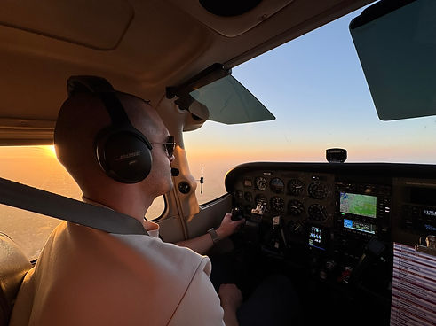


NORTHTRACK GENERAL AVIATION · iOS
Your flight. One coherent workflow.
NorthTrack connects learning, flight preparation, navigation and debriefing along one shared workflow.
Prepare your flight, keep the relevant information in view on the way, and then use your flight data for the debrief and for training.

EXPLORE NORTHTRACK
Jump directly to an area.
YOUR WORKFLOW
Four phases. One system.
NorthTrack puts tools and information where you need them – while learning, in flight preparation, on the way and after the flight.
01 — NAVIGATION & FLIGHT TECHNIQUE
Understand VOR. Not just memorise it.
Interactive training areas connect theory and application. VOR navigation, course relationships and other navigation fundamentals can be followed visually and practised deliberately.
From the single principle to the complete procedure.
In the Procedure Trainer, navigation procedures can be trained further in connected flight scenarios – including several VOR exercises and missions as well as ILS approaches under different simulated weather conditions.


02 — WEATHER & BRIEFING
Weather along your flight planning.
Look at departure, destination and other relevant points together with the available weather information, wind components and forecast periods.
Airport Weather & Briefing
Look at METAR and TAF, their development over time, wind components by runway and source information directly in the context of flight preparation.
Winds Aloft
Bring model-based wind and temperature information for different altitudes, positions and forecast times into your planning.
03 — FLIGHT CALCULATIONS
Understand the calculation. Not just the result.
NorthTrack connects flight calculations with visual training tools, so that relationships can be followed rather than merely computed.
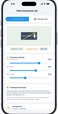
Wind & Components
Change wind direction, runway direction and the headwind, tailwind and crosswind components interactively, and follow their effect immediately.
Mass & Balance
Change loading and fuel and watch how mass and centre of gravity shift within the respective training model.
Aviation Calculations
Apply flying calculation methods such as the 1-in-60 rule in a structured way, with the matching units, assumptions and results.



04 — RADIO & COMMUNICATIONS
Understand radio work. Train communication.
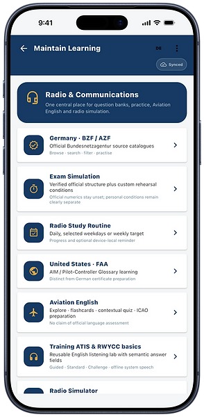
NorthTrack connects radio knowledge, Aviation English and interactive training areas – from structured learning to practical application.
Germany · BZF / AZF
Prepare for the German radio-telephony certificates with learning and practice areas based on the sources included in each case.
United States · FAA
Dedicated US training areas combine FAA-related radio content, Aviation English and pilot–controller terminology – kept clearly separate from the German BZF/AZF preparation.
Radio Simulator
Practise radio flows in interactive training scenarios and carry communication step by step from learning content into application.
ATIS Listening Trainer
Listen to ATIS-style training scenarios, pick out the relevant information and train listening comprehension at different difficulty levels.
05 — Offline & Aviation Data
Prepare. Take it with you. Keep the data status in view.
NorthTrack bundles regional offline charts, terrain, elevation and selected aeronautical data into prepared data packages. Regions can be made available on the device before the flight, and their installation and update status can be followed.
Offline Regions
Download available regions in advance and keep supported chart, terrain and elevation data on the device even without a permanent data connection.
Aviation Data
Supported regional aeronautical data – such as aerodromes, navaids and other navigation information – is provided within the respective data package.
Version & Update Status
Installation status, package version and available updates stay visible directly in NorthTrack, so it is clear which data status is present on the device.
Offline data supplements flight preparation and does not replace the current official aeronautical information or NOTAM checks that are required.

06 — GLIDE RANGE
Understand range. Make the options visible.
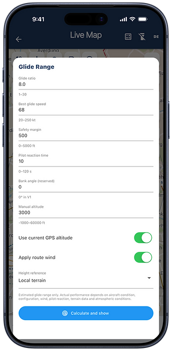
NorthTrack shows the estimated glide range in the map context, based on the assumptions you choose. That makes it possible to follow how altitude, glide performance, wind and safety margin affect the area that can be reached.
Glide Range
Set glide ratio, best-glide speed, safety margin and altitude reference, and look at the resulting estimated range on the map.
Terrain & Wind Context
Include terrain and – where enabled and available – wind in the display, in order to compare different assumptions directly with one another.
Training & Situational Awareness
Play through different starting situations and develop a better feel for how altitude, wind and aircraft performance affect the ranges that are possible.
The glide range shown is an estimate and does not replace flight manual data, a performance calculation or the decision of the pilot.
07 — FLIGHT MAP & TERRAIN
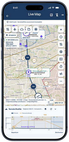
Route, airspace and terrain in one shared flight context
NorthTrack brings the prepared route together with chart, navigation and terrain information. Relevant layers can be shown or hidden as the situation requires, so that the display fits the task at hand.
Route & Aviation Map
Look at route, aerodromes, airspaces, navigation points and other available aeronautical data together on the map.
Terrain Profile
Show the terrain along the planned route together with the intended altitude profile, TOC, TOD and other available altitude information.
Layers & Context
Show or hide information layers such as airspaces and terrain as needed, and adapt the map to the current planning or flight context.
NorthTrack supports flight preparation and situational awareness and does not replace the current official aeronautical documents or NOTAM checks that are required.


08 — AIRCRAFT WALKAROUND
Not just ticking boxes. Understanding what you check.
The NorthTrack Walkaround combines a structured preflight flow with explanations of the individual check points. That turns a checklist into a learning area for student pilots and pilots at the same time.
Structured Walkaround
Work through the aircraft position by position, complete the individual checks and follow the progress of the whole preflight.
Inspect & Understand
For selected check points, see what is being checked, why it matters and what to pay particular attention to during the visual inspection.
Visual Learning
Images, typical findings and compact memory aids connect the real check point with its technical background.
The content serves training purposes and supplements the POH/AFM and checklist procedures that apply to the specific aircraft; those remain authoritative.
09 — AIRCRAFT & WEIGHT AND BALANCE
From the saved aircraft to the actual loading.
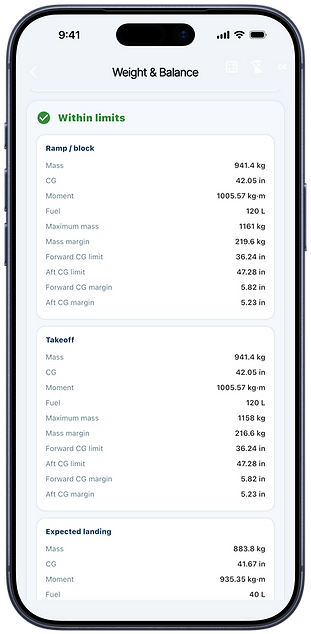
NorthTrack connects aircraft data and current loading values with flight planning. Mass and centre of gravity can be followed for the relevant flight phases and shown within the stored model.
Aircraft Profiles
Use supported baseline data, or create your own aircraft profiles on the basis of the aircraft documents that apply in each case and save them for later planning.
Mass & CG by Flight Phase
Look at mass, centre of gravity and the available margins for ramp/block, take-off and expected landing together.
Envelope & Fuel-Burn Path
Show the calculated points within the stored centre-of-gravity envelope and follow how mass and centre of gravity change with the planned fuel burn.
Responsibility for the correctness of self-created aircraft, loading and performance data lies with the user. The approved documents for the specific aircraft remain authoritative.

10 — COMMUNITY
Fly together. Connect deliberately.
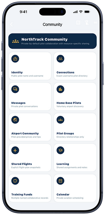
NorthTrack Community brings pilots together inside the NorthTrack environment. Connections, messages, groups and selected shared content create room for exchange and organisation around General Aviation.
Pilots & Connections
Find other pilots through the community functions provided, build connections and extend your own network.
Groups, Messages & Calendar
Use private conversations, pilot groups and shared organisational workflows inside NorthTrack.
Share deliberately
Share flights, learning content and other supported resources deliberately with selected people or groups.
Community and communication functions are subject to the respective age, safety and community rules of NorthTrack.